IS EARTHQUAKE AND VOLCANIC ACTIVITY INCREASING?
By Randy Mann and Cliff Harris
Within a matter of weeks, Planet Earth has experienced a swarm of earthquake activity. We’ve all heard about the deadly and catastrophic 9.0 magnitude quake that devastated northern Japan with its violent shaking and the huge tsunami it generated on March 11.
The earthquake was so strong that it shifted the Earth’s axis about 6.5 inches. This shift would affect how our planet rotates, not it’s position in space. According to the Jet Propulsion Laboratory in California, it’s estimated that the Japanese quake shortened Earth’s day by 1.8 microseconds as it increased the Earth’s rotation. The loss of time should not cause any type of time change, but may mark a slight difference in the passing of the seasons and also affect precise satellite navigation systems. And, according to the U.S. Geological Survey, it’s estimated that some parts of Japan actually moved 12 feet closer to North America as a result of the Earth’s violent movements.
Japan’s monster earthquake was tied for the 4th largest in recorded history. The largest was a 9.5 magnitude measured off the coast of Chile on May 22, 1960. The second largest shaker occurred on Good Friday, March 28, 1964 at Prince William Sound in Alaska. The magnitude was a 9.2 leaving Anchorage sustaining the highest property damage. The shock generated a tsunami that nearly destroyed many towns along the Gulf of Alaska and along parts of the West Coast. The quake was so strong that it was felt 4,000 miles away in Florida.
The third largest earthquake was the one off the West Coast of Northern Sumatra that registered a 9.1 on December 26, 2004. It generated the most deadly tsunami in recorded history as about 250,000 people were killed. On November 4, 1952, an estimated 9.0 quake struck Kamchatka, in far eastern Russia. It generated a tsunami that caused about $1 million in damage to the Hawaiian Islands, but, fortunately, no lives were lost.
Prior to the catastrophic quake in Japan, another earthquake that was a 5.8 magnitude struck southwestern China in the Yunnan Province. On March 10, a 6.5 earthquake hit Papua New Guinea. In Christchurch, New Zealand, more than 5,400 earthquakes have struck since September 4th.
In addition to the huge quake, four volcanoes erupted around the same time on March 11. Two of them exploded in eastern Russia, one in Indonesia and the other in southern Japan. According to one scientist, "Waves from the earthquake have been ringing the planet like a bell, causing stress in all sections of the planet."
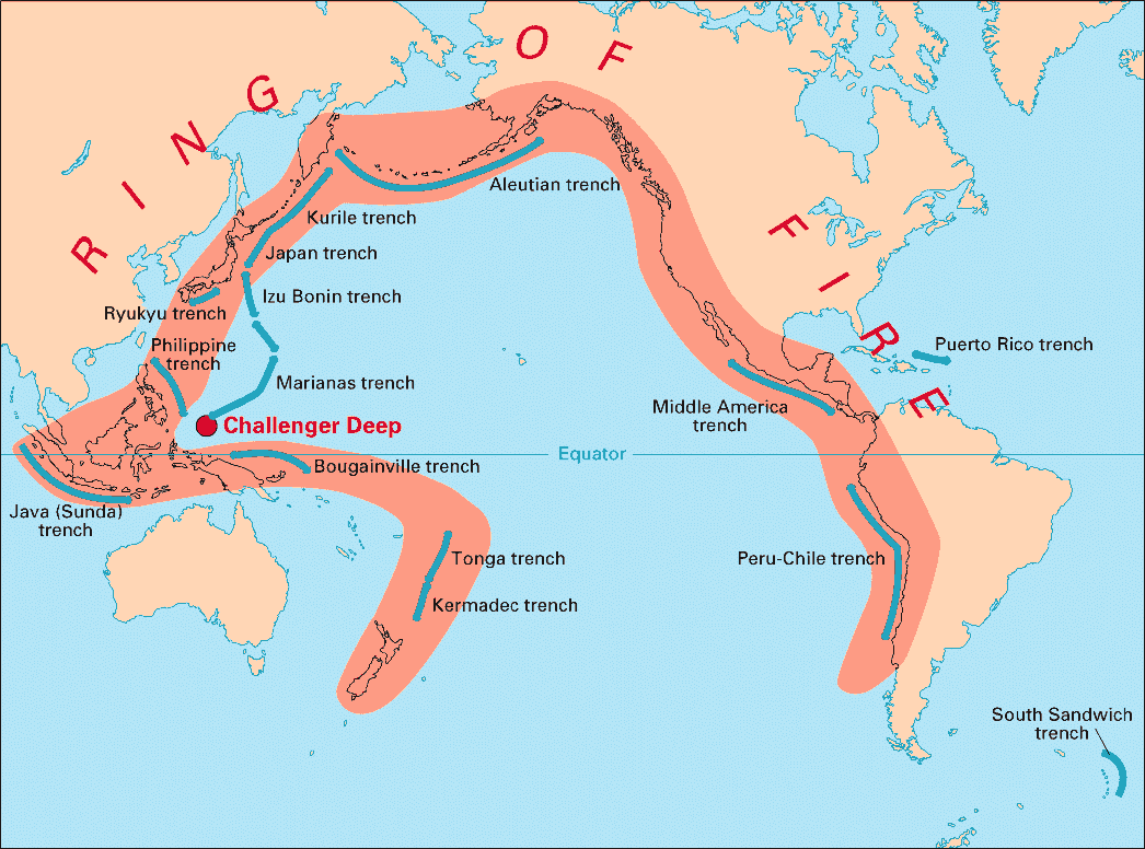
About 90% of the world’s earthquakes and 75% of the world’s dormant and active volcanoes like in a region that stretches approximately 25,000 miles. This region that looks like a horseshoe, the Pacific "Ring of Fire," primarily stretches from New Zealand northwestward through Indonesia, then northward across Japan, then eastward across southern Alaska and then southward along the U.S., Central American and South American West Coasts. It is the result of movement and collisions of huge crustal plates in the Earth’s crust.
So what does all this recent activity mean? No one knows for sure as earthquakes are extremely difficult to predict. Many scientists thought that a large earthquake was in store for northern Japan due to the recent earthquake activity prior to the 9.0 magnitude quake.
Several Russian scientists, however, are stating that large earthquakes are possible along the U.S. and South American West Coasts in the near future. Their information is based upon increasing subtle electromagnetic signals in the Earth’s upper atmosphere over these regions. But again, these are only educated guesses.
One of the next problem areas may be along the Pacific Northwest Coast. Seattle lies within the volatile "Ring of Fire." This region has been formed as the result of huge continental plates moving and sliding into one another. Many are familiar with the North American Plate and the Pacific Plate sliding past one another creating the notorious San Andreas Fault. Based on geologic data, a major earthquake has hit the Los Angeles area approximately every 200 years. The last major quake was about 300 years ago.
But, a smaller plate, called the Juan de Fuca, is located off the British Columbia, Washington, Oregon and extreme northern California coastline. New evidence suggests that it is currently pressing against the North American Plate causing uplift and stress. Eventually, it’s expected that the ground will break perhaps causing another "mega-thrust" earthquake that could rival the recent Japanese disaster.
But, no one knows for certain when that may happen or how strong the quake might be. It could be soon or many, many years down the road. Accurate earthquake prediction is not possible with our current technology. And, there are many people trying to make a name for themselves by making these predictions that may not come to pass for a long time.
According to a recent National Geographic documentary, there have been 19 major earthquakes in the northwestern U.S. over the last 10,000 years. The last one, based on carbon dating and Japanese writings, occurred around 1700 A.D. That major quake along the U.S. West Coast also triggered a tsunami that practically wiped-out the Japanese coastlines.
Some scientists believe that Seattle is overdue for a major earthquake. And, the epicenter could be more inland rather than offshore. Many of Seattle’s structures were not built to withstand a major earthquake, so damage in that city would likely be catastrophic.
According to some seismologists, "seismic activity is intensifying." They add, "the rate of occurring earthquakes has increased and the emission of energy has grown."
On average, since 1900, there is one quake with a magnitude of 8.0 or higher each year. (In 2007, there were 4.) There are approximately 17 quakes between a 7.0 and a 7.9 per year. According to the U.S. Geologic Survey, "Although it may seen that we are having more earthquakes, earthquakes of magnitude 7.0 or greater have remained fairly constant."
There has also been a large increase in the number of earthquakes that we have been able to locate each year because of the higher number of seismograph stations in the world and improved global communications. There are approximately 8,000 seismograph stations now compared to 350 in 1931.